Map
Click the map to access the official and latest DCNR map of Nolde Forest. Paper maps are also available at the kiosks in most parking areas.
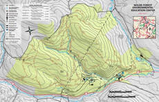
Click the map to access the official and latest DCNR map of Nolde Forest. Paper maps are also available at the kiosks in most parking areas.
Forest Plants
Want to learn about the plants in the forest? Here's a link to Nolde Forest Plants. This informative site is maintained by one of the groups most dedicated members!
Want to learn about the plants in the forest? Here's a link to Nolde Forest Plants. This informative site is maintained by one of the groups most dedicated members!
Recommended Hikes
Watershed Trail Loop
2.2 miles, easiest hiking
This trail begins at the Sawmill Parking Lot and allows visitors to walk up along the main artery through the forest--Punches Run. Incidentally, Punches Run is the name the Nolde Family called this land. Watershed Trail provides a gradual uphill walk from the historic sawmill up to the springs that feed Punches Run. Note that Watershed Trail briefly overlaps with the old mansion driveway and Boulevard Trail between Forester’s Bridge and the stone Mansion Bridge and take care to respect private property. Visitors can walk up Watershed Trail, which follows along the creek, then return downhill on Boulevard Trail, which is the single-lane gravel fire road that parallels the stream and overlaps with Watershed Trail in a couple locations.
As you ascend the narrow valley, you’ll zig zag back and forth over the stream on a series of narrow foot bridges. Watch your step and please avoid walking in the stream as this can be harmful to this very sensitive habitat. Along your way, take note of “Big Rock,” a 5’ x 5’ rounded chunk of conglomerate rock that has come to rest along Punches Run. Look closely at the way the large rock is made up of many smaller stones and pebbles held together by silt, sand, and clay.
As you reach the top of the watershed, you’ll see several concrete structures and pipes. Please leave them be. These are spring houses and an old water system that helps direct water further downstream. It is illegal to tamper with them. Once you reach the bench and map kiosk at the trail intersection, return downhill on “the high way,” Boulevard Trail where you’ll again see the stone Mansion Bridge, Forester’s Bridge and return to the Sawmill on the Watershed Trail.
Watershed Trail to Kissinger Road to Middle Road Loop
2.5 miles, easiest hiking
This trail begins at the Sawmill Parking Lot and allows visitors to walk up along the main artery through the forest--Punches Run until you cross Bridge at Kissinger Road heading south, then east before making the Kissinger Road, Middle Road Loop.
As you begin ascending the narrow valley, you’ll zig zag back and forth over the stream on a series of narrow foot bridges. Watch your step and please avoid walking in the stream as this can be harmful to this very sensitive habitat. Along your way, take note of “Big Rock,” a 5’ x 5’ rounded chunk of conglomerate rock that has come to rest along Punches Run. Look closely at the way the large rock is made up of many smaller stones and pebbles held together by silt, sand, and clay.
Once you cross Punches Run at Kissinger Bridge, walk uphill on the single-lane gravel fire road and follow sign posts for Kissinger and Middle Roads. Both are single-lane gravel fire roads that are mostly flat and pass through stands of spruce and mixed hardwood forest. There are other trail loop options that can be added on from there including Laurel Path or Cabin Hollow. Return to the Sawmill by walking downhill on Boulevard and Watershed Trails.
Boulevard Trail Loop
2.9 miles, easiest hiking
This trail begins at the Sawmill Parking Lot. Boulevard Trail is a lollipop-like loop that ascends uphill crossing the highest point in the park at 860-feet above sea-level. The trail also passes the Rock Outcrop at approximately 700-feet above sea-level and affords a glimpse of the Schuylkill River Valley through the trees.
From the Sawmill, begin walking upstream on Watershed Trail, crossing the Forester’s Bridge, and continuing upstream on the single-lane gravel fire road. Technically, you’re now on the old mansion driveway until you reach the stone Mansion Bridge where Boulevard Trail begins. From this bridge, continue walking uphill on the gravel roadway.
Up the trail from the stone Mansion Bridge you’ll reach an intersection where Watershed Trail, Apple Tree Trail, and Cabin Hollow branch off to your left. If you’re walking the Boulevard Trail Loop, stay straight/right. There you’ll see the Boulevard Privy. Whether you go straight, or turn right, you’re on Boulevard Trail Loop now and you will see this Privy again. Either way, you’re going uphill and will cross the highest point in the park.
Add on the Ridge Trail for an extended hike that winds along the ridge over Punches Run. Please help us minimize erosion and do not cut between Ridge Trail and the trails below.